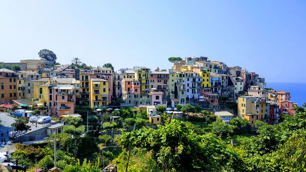
Vernazza and its harbour seen from the Sentiero Azzurro
Cinque Terre · Hike

The Sentiero Azzurro

The Blue Path: the old mule track that strings the villages together along the cliffs, through lemon groves and vines, to the view of Vernazza's harbour that sold the Cinque Terre to the world. The walk everyone comes for, and the one most often closed.

4 + 4 km1.5–2 h per stretchModerateCard required
Photo: The Cosmonaut via Wikimedia Commons
Home›Cinque Terre›Trails›Sentiero Azzurro
Overview

The path that joined five villages

Before the railway was cut through the cliffs in the 1870s, the only ways between the villages were by boat or on foot along this path. It is still the most beautiful way to arrive anywhere on the coast.

The Sentiero Azzurro, trail SVA 2 on park maps, once ran all the way from Monterosso to Riomaggiore. Today it is really two walks. Its southern half, Corniglia to Manarola, has been shut since a landslide in 2012 and is not expected back before about 2028; the flat Riomaggiore to Manarola section is the booked Via dell'Amore. What remains is the northern half: Monterosso to Vernazza, the hardest and most dramatic stretch, and Vernazza to Corniglia, gentler and more rural.

Neither is long, but both are stone steps more than path, climbing 200 metres out of each village and dropping back to the sea, often single file on narrow ledges above the water. On a spring morning, with the lemon trees in flower and the sea a hundred metres below, it is one of the great short walks of Europe. At noon in August, queuing on the steps behind a cruise group, it is not.

Before you go

Closed in autumn 2026, and what to walk instead

The park closed both northern stretches on 10 September 2026 for geological inspections, as it did for several weeks in autumn 2025, with no reopening date when this page went online. Paths also close after every orange or red weather alert, most often between October and December. Look at the Cinque Terre National Park's trail status page on the morning you walk; the barriers at each end are staffed and fines apply for entering a closed path.

If the coast path is shut, you lose less than you think. The vineyard route from Manarola over Volastra to Corniglia is the better walk anyway, and the sanctuary trails above Monterosso and Vernazza give the same views from higher up. The viewpoint over Vernazza's harbour, ten minutes up the path towards Monterosso, can usually be reached as far as the ticket barrier.

The vineyard path via Volastra →
View from the Sentiero Azzurro near Vernazza over a sandstone outcrop and the sea
The route

Monterosso to Corniglia, when it is open

Described north to south. Many walkers prefer Vernazza to Monterosso instead, which puts the steepest climb early and the view of Monterosso's beach ahead.

3002001000 m Monterosso Vernazza Prevo Corniglia 0 km3.5 km7.5 km

Approximate profile. Corniglia sits on its cliff about 100 metres above the sea.

  1. 0 km · Monterosso old town

    Up from the harbour

    The path leaves from the eastern end of Monterosso's old village, beyond the harbour, and climbs at once in stone steps through lemon groves and olive terraces. The first half-hour is the steepest of the whole walk; look back for the long curve of the Fegina beach and Punta Mesco.

  2. 1–2.5 km · The cliff path

    Terraces and ravines

    The path contours along the slope at around 150 to 200 metres, in and out of side valleys with tiny bridges over streams, past vineyards and a few farm huts, with drops to the sea on the right. Some sections are narrow; let people pass at the wider points.

  3. 3–3.5 km · The view

    Vernazza from above

    Rounding the last headland, the harbour appears below you, the church on the rocks and the Doria tower above: the photograph. The path then drops steeply through gardens straight into the village's main street.

  4. 3.5–5.5 km · Vernazza to Prevo

    The second climb

    From the top of Vernazza the path climbs again past the cemetery and through olive groves to Prevo, a hamlet of a few houses at about 200 metres and the highest point of the coastal path, with views back to Vernazza and forward to Corniglia's ridge.

  5. 7.5 km · Corniglia

    The village on the cliff

    A gentler, more rural stretch through vines and maquis leads to Corniglia, entering past the Guvano cliffs along Via Fieschi. Reward yourself with Alberto's basil gelato, then take the 382 steps of the Lardarina down to the station.

Practical notes

Before you set out

Tickets

Both stretches need a Cinque Terre Card: the Trekking card covers the paid paths and park buses for about €7.50 a day on green days; the Treno card adds unlimited trains, €22 to €35 a day depending on the day's colour. Buy online or at the stations; cards are checked at the barriers at each end.

Timing

  • Start by 8am in spring and summer, before the day boats and trains arrive.
  • Avoid cruise days when two or more ships are in at La Spezia.
  • Late afternoon is lovely, but leave time to finish in daylight.

What to bring

  • Shoes with grip: flip-flops fined from €50
  • A litre of water per two hours
  • Hat and sunscreen
  • Your Cinque Terre Card
  • Swimsuit for Vernazza's harbour

Getting back

All the villages are on the Levanto to La Spezia line, with Cinque Terre Express shuttles every 15 to 30 minutes from mid-March to 1 November. From Vernazza or Monterosso, the hop-on boats are the scenic return from late March to early November.

More Cinque Terre walks

Where to walk next

Photography

Photo credits

Wikimedia Commons photographs are used under their Creative Commons licences; Pexels photographs under the Pexels licence. Click a title for the original, its author and licence.

Powered by Webloyt | Report abuse